Kansas Springs
Rex Buchanan
Public Outreach, Kansas Geological Survey
Robert Sawin
Public Outreach, Kansas Geological Survey
Wayne Lebsack
Independent Geologist
Introduction
For thousands of years, the springs of Kansas have served as important sources of water for human consumption. The activities of Native Americans—hunting expeditions, camping, and settlement sites—converged around springs. The routes of historic trails were determined by springs, such as Alcove Spring on the Oregon Trail or Diamond Spring along the old Santa Fe Trail. From Bonner Springs to Baxter Springs to Sharon Springs, towns grew up in locations where spring water was available. Even before the arrival of people on the Great Plains, springs sustained rivers and streams and provided reliable habitat for plants and animals. Springs are an important component of the Kansas landscape; they aid in understanding the connection between groundwater and surface water and the impact of human activities on the environment.
Despite the historic, geologic, and environmental importance of springs, little information has been systematically collected about them in Kansas. No comprehensive inventory of their locations has been made. Few scientific publications devote more than a few paragraphs to them; references are scattered throughout the literature of various disciplines. The purpose of this circular is to describe the basic geologic conditions that create springs, discuss some of the better-known or more prolific springs in the various regions of the state, and establish their significance, both as a source of water for individuals and communities, and information about the landscape. Bolded terms are defined in the Glossary at the end of this publication.
Springs Defined
One of the earliest technical definitions of a spring was "a place where, without the agency of man, water flows from a rock or soil upon the land or into a body of surface water" (Meinzer, 1923). This definition contains several key components—water must flow, not simply stand, and it must flow naturally, not as a result of human activity. This definition differentiates a spring from a seep, which is defined as a discharge of water that "oozes out of the soil or rock over a certain area without distinct trickles or rivulets" (Bouwer, 1978). Another definition was developed by Walter Schoewe, who wrote extensively about the geology of Kansas; he defined springs as places where water flowed "in a distinctive current" (Schoewe, 1953). Another definition states that springs generate water in amounts sufficient to "form a channel on the earth's surface" (Webb et al., 1997). For the purposes of this circular, springs are defined as places where groundwater flows naturally from the earth into a body of surface water or onto the land surface, at a rate sufficient to form a current.
Geology of Springs
Springs, then, are places where groundwater moves naturally to the earth's surface. Because groundwater is underground and unseen, it is not always possible to know exactly how movement takes place. In addition, each spring differs according to the geology and topography of an area. Nonetheless, it is possible to describe the general geology of springs.
Spring water begins with precipitation that falls on the land's surface and moves down into the subsurface. That water continues to be drawn down through permeable material by gravity until it encounters a less permeable layer of rock, such as shale. While many rock layers appear to be perfectly horizontal, most have a slight incline, or dip. In Kansas, many rock units dip subtly to the west—that is, they get slightly deeper as you go from east to west across the state. Groundwater moves downdip, along the contact of the permeable and less permeable rock, until it reaches a location where erosion exposes the rocks to the atmosphere, such as a stream valley or hillside, creating an outlet for the water to move onto the land. This is called a contact spring (fig. 1), the most common type of spring in Kansas.
The contact spring model works well in consolidated rocks such as limestone, sandstone, and shale that are common in Kansas. The layering that is typical of these rocks makes it easier to understand the mechanisms that create the springs. Contact springs can also occur in unconsolidated material, such as sand and gravel. Because unconsolidated materials are not uniformly layered (clay layers or lenses, for example, occur randomly and discontinuously within the sand and gravel bodies), the exact movement and mechanism of springs from unconsolidated material are more difficult to describe, especially if artesian conditions exist.
Most Kansas springs are gravity springs, where water flows to the surface by the action of gravity, as at contact springs. However, in a few of the state's springs, water is forced to the surface by artesian pressure. Under artesian conditions, the pressure in an artesian aquifer is greater than the pressure at the land surface. When the aquifer is tapped (naturally or by a well), the higher pressure in the aquifer forces the groundwater to the surface, either as an artesian spring or flowing artesian well (fig. 2). Artesian springs were more common in the state before heavy pumping lowered the water table and lessened the pressure that might have created artesian conditions.

Figure 1. Contact spring. Gravity moves infiltrating water downward and then laterally in the downdip direction on top of the less permeable rock layer.

Figure 2. Artesian spring. Water under artesian pressure rises to the land surface.
Kansas Springs by Physiographic Region
One way to group the state's springs is according to physiographic region (Schoewe, 1949), based on the physical characteristics of the land (fig. 3).
Each of those physiographic regions is distinct, and each has springs—in some regions they are relatively common; in others they are rare. The following description is meant only to be illustrative of a few of the major springs of each region. The list is not meant to be exhaustive. Most of these springs are on private property, and visitors should have landowner permission before entering.

Physiographic Regions of Kansas
Glaciated Region
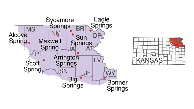
The northeastern tip of Kansas was covered by glacial ice roughly 600,000 years ago. That ice sheet covered an area from about the Kansas River on the south to the Big Blue River on the west. Mineral water springs, developed as resorts and spas, were common in this area in the late 1800s (Bailey, 1902), in locations such as Eagle Springs (Doniphan County), Bonner Springs (Wyandotte County), or Arrington Springs (Atchison County). Prolific springs continue to flow at Sycamore Springs and Sun Springs (Brown County); both areas are used today as resorts. Alcove Spring (Marshall County) and Scott Spring (Pottawatomie County) were well-known stops along the Oregon Trail. Both continue to flow, and both are either in or near public parks. Maxwell Spring (Nemaha County) still provides water for the town of Seneca.
Osage Cuestas and Cherokee Lowlands
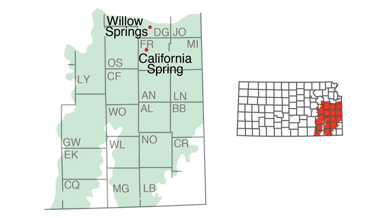
This is an area of interbedded limestones and shales, mostly Pennsylvanian in age, that create slightly rolling hills in the eastern third of the state. Large springs are relatively uncommon here. Several historic springs, such as California Spring (Franklin County), were found along trails that cut across this area. Willow Springs, a stop along the Santa Fe Trail, continues to flow (Domer, 1996), as do springs in the vicinity of the town of Big Springs (Douglas County), though the latter have been altered by the construction of Interstate 70.
Ozark Plateau
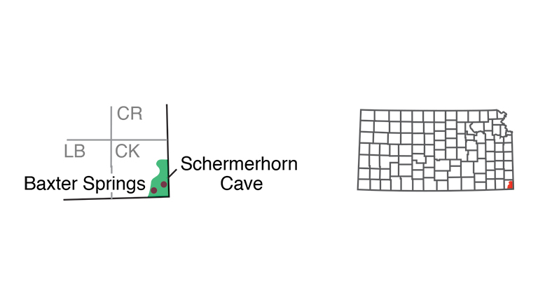
The very southeasternmost corner of Kansas is part of the Ozark Plateau, a region that is generally associated with Missouri and Arkansas. The bedrock here is Mississippian in age, deposited about 330 million years ago, making it the oldest rock exposed at the surface in Kansas. The high levels of precipitation here, averaging as much as 40 to 45 inches per year (Goodin et al., 1995), along with the cavernous nature of the limestone, are conducive to the formation of springs. A spring issues from Schermerhorn Cave in the city park south of the town of Galena, creating an environment for rare animals, such as orange cave salamanders (Gress and Potts, 1993). At Baxter Springs, on the edge of the Ozark Plateau, mining has altered the subsurface rocks, changing the nature and flow rates of springs in the town.
Chautauqua Hills
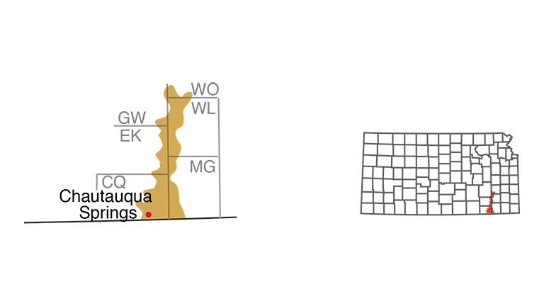
A thick layer of sandstone creates the distinctive geology and vegetation of this area, which extends north through Chautauqua and Elk counties, and beyond. A mineral-water spa was constructed in the late 1800s at Chautauqua Springs in the town of Chautauqua. This spring, on the east edge of town, continues to flow, as do others in the area.
Flint Hills
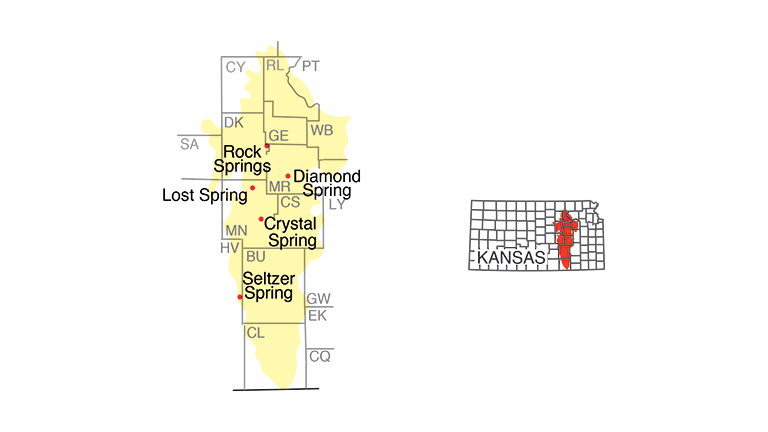
This strip of hills, extending north to south across east-central Kansas, consists primarily of interbedded limestones and shales of Permian age. Many of the limestones contain chert, commonly known as flint. Chert resists erosion, so the soils here are relatively thin and much of the area remains in native prairie grasses, used primarily to pasture cattle. Because much of the area is relatively undisturbed, a number of the well-known springs in the Flint Hills continue to produce large amounts of water. One of the largest springs in the state, Rock Springs (Dickinson County) at Rock Springs 4-H camp (fig. 4), flows at around 1,000 gallons a minute, continuing to provide water for the camp.
Diamond Spring (Morris County) and Lost Spring (Marion County) were famous Santa Fe stops that continue to flow. Crystal Spring (Marion County) provides the town of Florence with its water supply, which the local water-tower advertises as 99.96% pure (an analysis that is fairly accurate). Springs in Flint Hills pastures in Chase County, and farther to the south in Cowley County, continue to flow at rates of several hundred gallons per minute.

Wellington-McPherson Lowlands
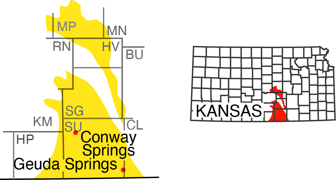
These are areas south of the city of Wichita and around the city of McPherson. The predominant bedrock is shale, which has been eroded to form a relatively flat landscape. Geuda Springs (Sumner County), on the edge of the Wellington Lowlands, was developed as a mineral water spa in 1886, with a hotel and its own lake (Bailey, 1902); the area is mostly dry today. The spring at Conway Springs (Sumner County) was once used for bottling and is today marked by a spring pavilion in a park in the center of town. Seltzer Spring (Sedgwick County) is relatively high in sulfates because of gypsum in the underlying shale.
Arkansas River Lowlands
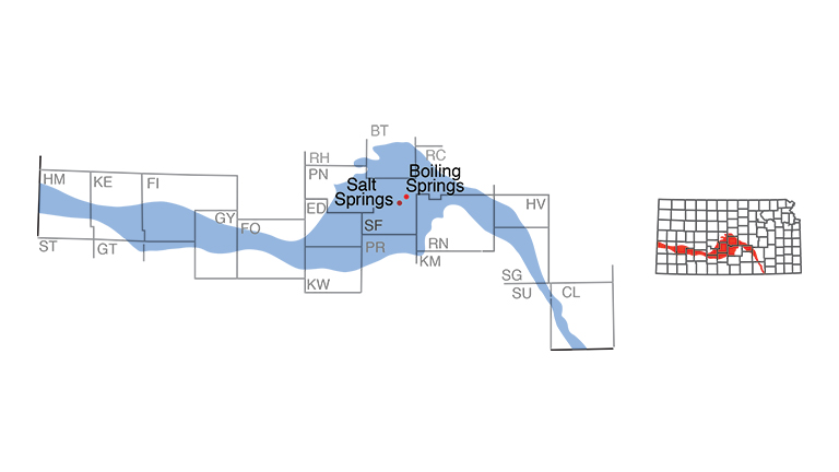
This area of sands, gravels, and other largely unconsolidated material was laid down by the Arkansas River from its entry in the western end of the state until its exit near Arkansas City. The area is largest south of the river's sweeping bend in central Kansas. Seeps and springs in Stafford County provide part of the water that supports the salt marshes at Quivira National Wildlife Refuge. Boiling Springs (Stafford County) flows at the rate of about 20 gallons per minute. Salt Springs (Stafford County) is high in chlorides and is salty to the taste.
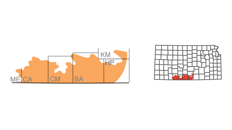
Red Hills
This is an area of gypsum, siltstone, and sandstone, colored brick-red by iron oxide, giving the hills their name. Like the Flint Hills, much of this area remains in native grass; also, gypsum is soft and easily dissolved by groundwater, creating caverns and passages for the movement of water. However, because of the relative lack of precipitation, averaging less than 25 inches per year (Goodin et al., 1995), springs are somewhat rare and most of them are fairly small. Springs in the pastures of Clark County, for example, provide water at a rate sufficient for pastured livestock.
Smoky Hills
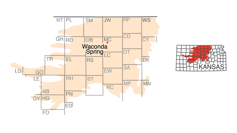
This region is marked by the sandstones, limestones, and other rocks deposited in the Cretaceous Period of geologic history, about 100 million years ago. It includes outcrops of such rock units as sandstones in the Dakota Formation and limestones and shales in the Greenhorn Limestone (one layer of which is known locally as fencepost limestone). What was perhaps the state's best known spring, Waconda Spring, once existed here in Mitchell County. This location was sacred to Native Americans (it was also known as Great Spirit Spring) and was later the site of a mineral water spa and hotel. Water from the spring deposited a large mound of the mineral travertine around it. Today it is covered by the waters of Waconda Lake. Numerous smaller springs continue to flow in pastures in the Smoky Hills; some are accompanied by petroglyphs inscribed by Native Americans on nearby outcrops of Dakota sandstone. Springs are also common in the Blue Hills area of Russell and Ellis counties.
High Plains
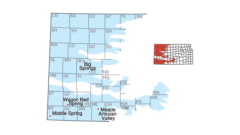
Covering the western third of Kansas, this area is largely mantled by sands, gravels, silts, and other rock debris that were washed out onto the plains from the Rocky Mountains to the west, over the past several million years. The Ogallala Formation is the most prolific aquifer in this area, and it provided the water that supported flow in many of the historic springs. With the depletion of the Ogallala because of irrigation, however, some of these springs no longer flow. Wagon Bed Spring, also known as Lower Spring (Grant County), was a stop on the Dry Route, or Cimarron cutoff, of the Santa Fe Trail; today the spring is dry. Middle Spring (Morton County), in the Cimarron National Grassland, was another camping spot on the trail; it continues to produce small amounts of water, though it is more of a seep than a spring. Springs in the Meade Artesian Valley (Meade County) have been dried up or greatly reduced as a result of lowered water levels, though a flowing artesian well continues to produce water at Lake Meade State Park. Big Springs (Scott County) at Lake Scott (fig. 5) continues to produce large amounts of water that flow into Ladder Creek.

Significance of Springs
Springs are fascinating natural phenomena. Their origin is seemingly mysterious; they appear suddenly, almost anywhere. They can smell like rotten eggs, taste salty, or be as pure and clean as water can be. Their presence produces a green and living landscape, often creating an oasis in the middle of dry places. Purported therapeutic properties associated with springs have provided people with hope and relaxation for centuries. In the 19th century, someone who had tried the water cures at nearly all of the spring-water spas in an area, without success, was "down to their last resort" (Chapelle, 1997).
Springs are of historic interest (Buchanan et al., 2000). They mark the path of trails, and they serve as places where people have come together for centuries. Several Kansas municipalities rely on springs for public water, and hundreds of smaller springs across the state provide water for domestic use, for watering livestock, for fishing ponds, and for other uses. When water is in short supply, springs may become even more important sources of water.
Springs are also important to the flora and fauna of the state, especially in the parts of Kansas where surface water is rare. In addition to serving as watering sites, springs provide important habitat. Many varieties of plants (watercress and monkeyflower are two common examples) thrive in spring runs, the channels where water moves away from a spring. Some fish species flourish in spring runs, and the Kansas Biological Survey has reported a riffle beetle that is found only in Big Springs at Lake Scott (Ferrington et al., 1995).
Springs are a window into the aquifer; their presence reveals the groundwater potential and may help locate a source of useful water. Springs are excellent indicators of the general state of the hydrologic system. When groundwater levels decline, either from pumping or a lack of precipitation, the change is nearly always reflected in lessened spring flow. Many springs in western Kansas have stopped flowing as a result of lowered water tables, primarily from pumping the Ogallala aquifer, whereas springs in the Flint Hills, where irrigation is uncommon, have continued to flow.
Finally, springs are a source of information about groundwater quality. Poor-quality spring water is a reflection of the water quality in the aquifer that feeds the spring. In some cases, poor water quality is due to natural causes. In Kansas, highly saline water is fairly common, reflected in locations such as Salt Springs. In other cases, groundwater dissolution of gypsum can lead to water that is high in sulfates, a situation found in springs on the west edge of the Flint Hills. Poor-quality water in springs can also result from human activity. At least one spring associated with the Arkansas River in western Kansas is now high in sulfates from reuse of the water, mostly for irrigation. Another spring in eastern Kansas shows elevated levels of contamination from hazardous-waste sites more than a mile away. Several springs in the rest of the state show elevated levels of nitrates, probably related to agricultural activity.
References
Bailey, E. H. S., 1902, Special Report on Mineral Waters, v. 7: University Geological Survey of Kansas, 343 p.
Bouwer, H., 1978, Groundwater Hydrology: New York, McGraw-Hill, 480 p.
Buchanan, R., Sawin, R., and Lebsack, W., 2000, Water of the Most Excellent Kind—Historic Springs in Kansas: Kansas History, v. 23, p. 128–141.
Chapelle, F. H., 1997, The Hidden Sea—Ground Water, Springs, and Wells: Tucson, Arizona, Geoscience Press, 237 p.
Domer, D., 1996, Water in Willow Springs Township: Kansas History, v. 19, no. 1, p. 64–80.
Ferrington, L. C. Jr., Kavanaugh, R. G., Schmidt, F. J., and Kavanaugh, J. L., 1995, Habitat Separation among Chironomidae (Diptera) in Big Springs: Journal of the Kansas Entomological Society, v. 68, no. 2, p. 152–165.
Goodin, D. G., Mitchell, J. E., Knapp, M. C., and Bivens, R. E., 1995, Climate and Weather Atlas of Kansas: Kansas Geological Survey, Educational Series 12, 24 p.
Gress, B. and Potts, G., 1993, Watching Kansas Wildlife—A Guide to 101 Sites: Lawrence, University Press of Kansas, 104 p.
Meinzer, O. E., 1923, Outline of Ground-water Hydrology, with Definitions: U.S. Geological Survey, Water-Supply Paper, no. 494, p. 48–59.
Schoewe, W., 1949, The Geography of Kansas—Part II, Physical Geography: Transactions of the Kansas Academy of Science, v. 52, no. 3, p. 261–333.
Schoewe, W., 1953, The Geography of Kansas—Part III, Hydrogeography: Transactions of the Kansas Academy of Science, v. 56, no. 2, p. 131–147, 187–190.
Webb, D. W., Wetzel, M. J., Phillipee, L. R., Reed, P. C., and Young, T. C., 1997, Illinois Springs: Illinois Natural History Reports, no. 345, p. 2–3.
Glossary
Aquifer: A geologic formation capable of holding and yielding significant amounts of groundwater.
Artesian aquifer: An aquifer in which groundwater is confined under pressure significantly greater than atmospheric pressure. This pressure, called artesian pressure, is generally due to the weight of water at higher levels in the same zone and is sufficient to cause water to rise above the level of the aquifer in a well or natural fissure. An artesian aquifer is bounded above and below by confining beds of less permeable rock. Syn: confined aquifer.
Contact: A plane or surface between two different types, or ages, of rock.
Contact spring: A type of gravity spring whose water flows to the land surface from permeable rocks that are underlain by less permeable rocks, preventing the downward movement of water.
Groundwater: Underground water that is generally found in the pore space of rocks or sediments.
Permeable: Permeability is a measure of the ease with which a fluid will move through a porous material (e.g., sand and gravel or rock). A geologic unit is permeable if groundwater moves easily through it.
Seep: A discharge of water that "oozes out of the soil or rock over a certain area without distinct trickles or rivulets" (Bouwer, 1978).
Spring: A place where groundwater flows naturally from the earth into a body of surface water or onto the land surface, at a rate sufficient to form a current.
Surface water: Water found at the earth's surface, usually in streams or lakes.
More
Kansas Geological Survey
Public Information Circular 11
October 1998; revised May 2008

