Teacher Resources
How can the KGS help your classroom?
The Kansas Geological Survey supports our teachers through two different means; providing in-person and virtual visits to your classroom, and activities that you can download and give to your students. If you would like to arrange a visit or need help with the activities, send an email to our educator, Andy Connolly at andrewco@ku.edu.
In-Person Visits and Teaching Modules
If you live in northeast Kansas, you can arrange an in-person visit from our educator who can engage your class with the following teaching modules. These modules are flexible and can tackle different grades depending on the learning goals. To arrange a visit please contact KGS Outreach at kgssocials@ku.edu. We can also cover other geology topics if needed such as the geologic history of your area and aquifers.
Rocks and Minerals-Observe rocks and minerals and learn how we can identify them using the streak test, scratch test, fluorescent lighting and more. Learn about the common rocks and minerals of Kansas and how they were formed.
Fossil Habitats of Kansas-Observe fossils from four different time periods and habitats of Kansas; Paleozoic Seas, Paleozoic Forests, Mesozoic Seas, and Pleistocene Plains. Learn how Kansas has changed over millions of years and identify common fossils across Kansas.
Earthquakes of Kansas-Our newly developed teaching kit! Learn how earthquakes form, where they occur in Kansas, the dangers of soil liquefaction, and how we can construct buildings to resist earthquakes. Students can make their own waves and watch them form with our seismograph. Our new shake-table will also give students to chance to make building models and see how well they'll fare in an actual earthquake.
We also loan rock and mineral teaching kits, if you would like to check one out for your classroom just contact us at the above email.
Downloadable Teaching Material
The Kansas Geological Survey is developing standards-based, educational resources for Kansas teachers. Check out these free activities based on NGSS standards and teach your class about geology! Check back every now and then for updates and new material.
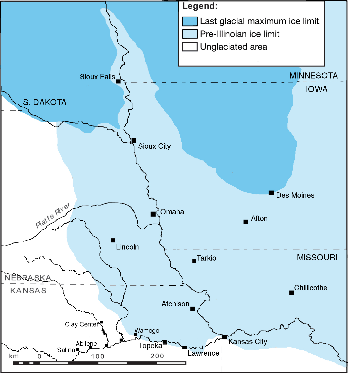
Summary: During the Ice Age, glaciers reached as far south as Kansas. But how did we know they were here? And what was their effect on the landscape? In this section, students will learn about the Glaciers of Kansas, understand how glaciers change the landscape, and make their own glacial model using slime!
Standards: 4-ESS1-1, 4-ESS2-1, MS-ESS2-2
Activities:
Glaciers of Kansas Video Companion (docx) (MS)
Track a Glacier (docx) (MS)
Model a Glacier Slime Activity (docx) (ES and MS)
Further Info:
Glaciated Region of Kansas
Summary: The Ogallala Aquifer is the most prominent aquifer in Kansas. Farmers, ranchers, and communities across western Kansas use the underground water source every day. However, years of pumping have drained the Ogallala and its status is in jeopardy. These activities are designed for a middle and high school audience and teach students how aquifers are formed, where Kansans get their water, and how we can achieve sustainable pumping of our aquifers.
Standards: 4-ESS2-2, MS-ESS3-1. MS-ESS3-3, MS-ESS3-4, HS-ESS3-1, HS-ESS3-6
Aquifers of Kansas Video: A short documentary detailing the aquifers of Kansas and how they were formed. (MS and HS)
Aquifers of Kansas Video Companion Worksheet
Aquifers of Kansas Video Companion Worksheet-Answers
Map Activity: Studentsread a Kansas precipitation map and a county water source map. Students will understand where their water comes from, how it differs across the state, and how precipitation affect our water sources. (ES, MS and HS)
Map Activity Worksheet
Map Activity Worksheet-Map Supplement
Map Activity Worksheet-Teacher Answers
Aquifer Model: Students build their own aquifer model using sand, a bucket, a toilet paper roll, and a soap pump. Students will understand how water can be stored underground and how scientists measure the depth of water in aquifers. They can experiment with different types of pumps or soil material to understand the effects of those variables on underground water. (MS and HS)
Aquifer Model Activity Sheet
Aquifer Model Activity Sheet-Teacher Edition
Aquifer Well Level Analysis: Study the High Plains aquifer map and chart changing water levels over the past half century. This activity uses the High Plains Aquifer Interactive Atlas, which contains decades of data gathered from more than 1,400 wells across the state. Students will need a computer. (HS)
High Plays Aquifer Interactive Atlas Website
Aquifer Well Level Analysis Activity Sheet
Further Info:
Aquifers in Kansas
An accessible version of the documents on this site will be made available upon request. Please contact the KGS editor at kgs-editor@ku.edu to request the document be made available in an accessible format.