OGALLALA: The Groundwater Game

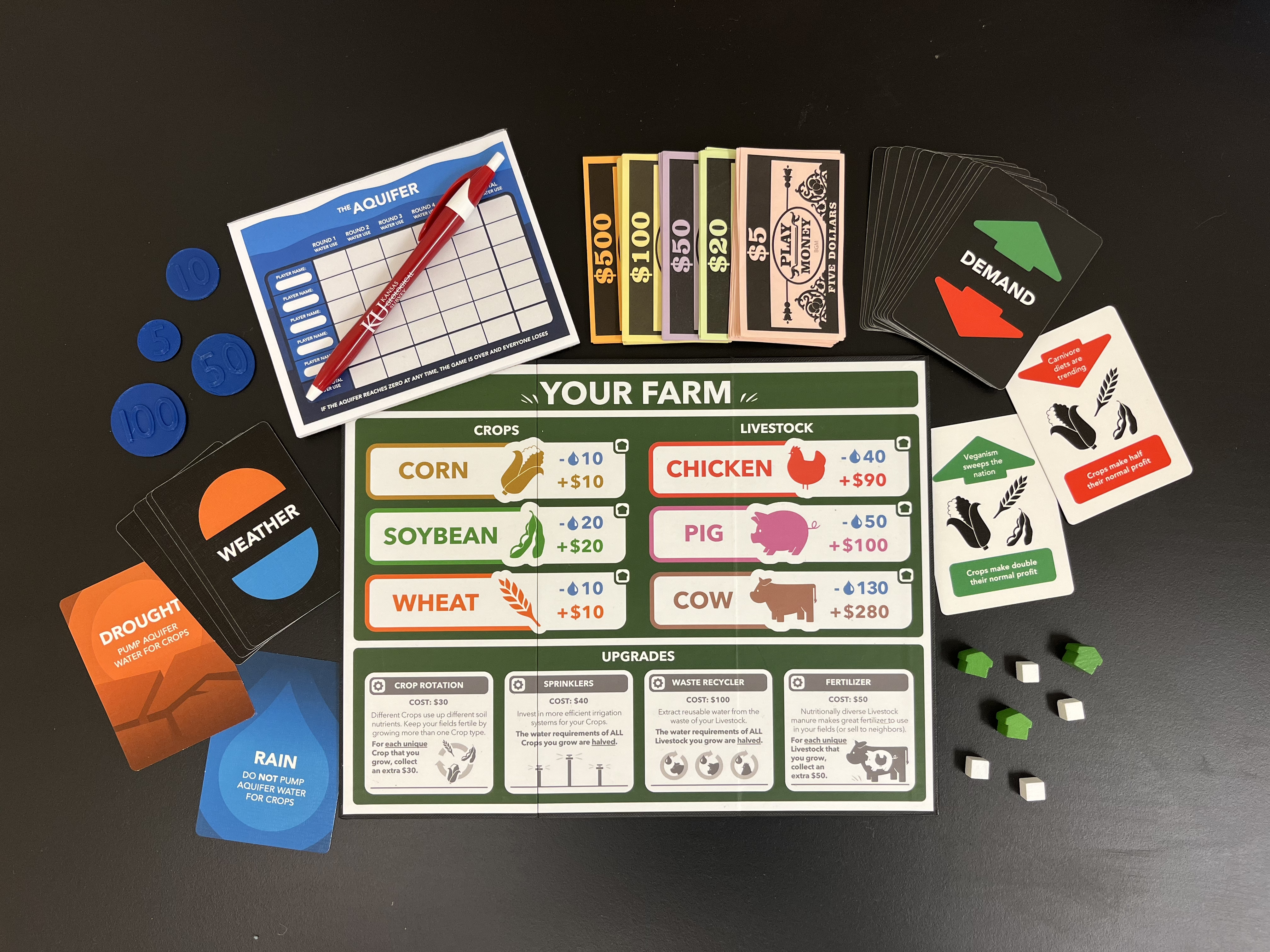
OGALLALA is a two- to five-player board game created by the Kansas Geological Survey's Outreach team to help middle school students learn about aquifers and water use management. Sunday Siomades led the game’s creation, with help from Andy Connolly and Blair Schneider. Players take the role of western Kansas irrigators who rely on groundwater from the Ogallala aquifer to support the crops and livestock on their farms. The player with the most money at the end of five rounds wins. However, if players run out of aquifer water, the game is over and everyone loses.
Access the complete game rules by downloading the OGALLALA Print and Play Rules.
Original Kansas Geological Survey OGALLALA game materials
Game Materials
Print and Play Rules (PDF 97KB)
Farm Board (PDF 139KB)
Aquifer Sheet (PDF 32KB)
Weather Cards (PDF 327KB)
Event Cards (PDF 1.6MB)
Money Sheet (PDF 91KB)
Discussion and Questions (PDF 112KB)
How to Play Video
This video goes over the rules for the OGALLALA game including setup, playthrough, and ending the game. Note: The Print and Play OGALLALA version uses a Money Sheet and Aquifer Sheet rather than the tokens and dollar bills seen in the “How to Play” video.
What to Print for One Game of OGALLALA
- 1 Farm Board per player (1 copy of the "OGALLALA_farm_board" PDF per player)
- 1 Money Sheet per player (1 copy of the "OGALLALA_money_sheet" PDF per player)
- 1 Aquifer Sheet (1 copy of the "OGALLALA_aquifer_sheet" PDF)
- 6 Weather cards (1 copy of the "OGALLALA_weather_cards" PDF)
- 16 Event cards (1 copy of the "OGALLALA_event_cards" PDF)
Note: It is recommended to print the Weather and Event cards onto thick paper so they are not see-through. The Weather and Event card PDFs are structured for double-sided printing. Both PDFs are sized for standard 8.5 x 11-in. paper (each card will be one sheet).
Additional Materials for Gameplay
- 3 Farm Tokens per player
- 4 Upgrade Tokens per player
Note: The Tokens can be any small matching item (beans, beads, paperclips, etc.). Players will move the tokens around on their Farm Board to indicate Crop/Livestock and Upgrade selections. Farm Tokens and Upgrade Tokens should be different items so they are not confused with each other.
- 1 writing implement per player
- Calculators (optional; for expedited play)
About the Game
Where did the numbers come from?
The water use of each Farm product in the game was derived from the GRACE Communications Foundation’s “The Water Footprint of Food Guide,” an interactive web application that shows the amount of water required to produce a single serving of food. The Guide was acquired by EcoRise in 2024 is featured on the Water Footprint Calculator website.
The gallons of water consumed in the production of a 4oz serving of each of the six Farm products was converted to a simplified ratio (using corn, the lowest quantity) that was then scaled up to create a water “cost” for the game:

The game compares water use among the six Farm products, but does not proportionally scale water use to the quantity of water in the real-life Ogallala aquifer; for example, a single Cow uses 5.2% of the total available water in a five-player game (players start with 2,500 water units, and Cows consume 130 water units). The water consumption of each Farm product refers to all the water that farmers need to grow the product in real life; while the Crop products require water via irrigation, the primary water use of the Livestock products is crop production for their feed (rather than direct ingestion by the Livestock).
The income generated by each Farm product was derived from an August 2025 USDA National Agricultural Statistics Service report (ISSN: 1937-4216) that included July 2025 prices farmers across the United States received for their crop and animal products. The reported price received for each product (by weight) was converted to price received per 4oz serving. This per-serving price was then scaled up and rounded for the game.

The quantity of water in the “Aquifer” (represented on the Aquifer sheet) is not based on actual Kansas groundwater reserves. The quantities of water were chosen to maintain the difficulty of the game for groups of varying size.
The Weather Cards
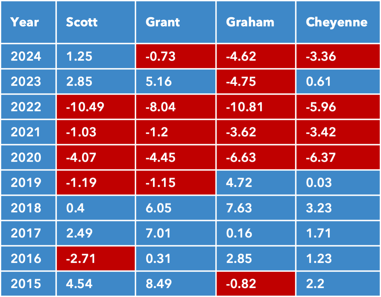
There are six Weather cards in the game: three Rain and three Drought. Cards are not shuffled back into the deck when they are flipped. This is consistent with precipitation records for western Kansas, which indicate that conditions are annually “drier than normal” about every other year, on average. This was determined using the "departure from normal" precipitation values from Scott, Grant, Graham, and Cheyenne counties over a 10-year (2015–2024) period (see below). The red cells in the table below indicate a year when conditions were drier than normal. “Normal” refers to the current long-term (30-year) U.S. climatological average based on data for 1981–2010. These four counties were selected for their distribution over western Kansas.
The Demand Cards
There are 16 Demand cards (Figure 2c) in the game: a positive and negative card for each individual Farm product, and a positive and negative card for (1) all Crops and (2) all Livestock. This element of the game demonstrates that the sell prices of agricultural products fluctuate year to year.
The Upgrades
The four Upgrades in the game are based on real technologies and strategies that farmers employ to save money (and water). The prices associated with each Upgrade are not reflective of actual installation/implementation costs, but were chosen in approximate scale to the other financial mechanisms of the game.
Crop Rotation
Growing one kind of crop (e.g., corn) in a field year after year depletes that field of the specific nutrients the crop consumes. Without fertilizer to supplement the nutrient loss, the field becomes less fertile and its crop yields decrease. By alternating crops (e.g., planting corn every other year and soybeans the years in between) and diversifying nutrient inputs and outputs, farmers save money on fertilizer.
Sprinklers
Technology evolves rapidly, and many newer models of sprinklers use water and power more efficiently than older models. Though there is a cost associated with upgrading to newer technology, farmers can save money in the long term on water and energy bills.
Waste Recycler
The type of real-life waste recycler described in this game typically operates by applying heat and/or pressure to dehydrate organic waste. This process yields water and dried waste. The water can be treated and recycled for irrigation, running other farm equipment, or domestic use; dried waste can be used as fertilizer or discarded (less expensively than wet waste due to its decreased weight). Recycling waste in this way can decrease a farm’s groundwater pumping demands.
Fertilizer
Nutrient-rich animal manure, especially if it comes from more than one type of animal, is great fertilizer. Crop farmers without animals often spend money on manure to enrich their fields. By using or selling manure as fertilizer, farmers can increase profits.
About Aquifers
What and where is the Ogallala aquifer?
Aquifers are underground layers of rock saturated with water. Aquifers form when surface water seeps into soil and sediment, migrating down through the subsurface until it meets impermeable bedrock. There, in the cracks and crevices of the rock layers atop the bedrock, water accumulates. We call this subsurface water groundwater.
Aquifers exist at a variety of depths — some regions are just under the surface, while others are dozens to hundreds of feet underground. Shallow regions accumulate water quickly, while it may take months or years for water to make its way down to deeper regions.
There are 37 major aquifer systems around the globe. One of these systems is the High Plains aquifer, which stretches beneath eight states (South Dakota, Nebraska, Wyoming, Colorado, Texas, New Mexico, Oklahoma, and Kansas) across almost 112 million acres. The High Plains aquifer has three Kansas regions: the Ogallala, the Great Bend Prairie, and the Equus Beds. The largest region, the Ogallala, is made of a rock formation of the same name.
Most of the groundwater pumped in Kansas is from the aquifer contained by the underground layers of the Ogallala Formation.
High Plains Aquifer Regions in Kansas

Click for larger image
The Ogallala aquifer’s name is derived from the Oglala tribe, one of seven subtribes of the Lakota people. “Oglala” means "scatter,” or "to scatter one's own.” The Ogallala aquifer was named after the town of Ogallala, Nebraska, where the Ogallala rock formation was first documented. Geologist N. H. Darton is credited with naming both the formation and the aquifer.
How Much Water Is There?
Groundwater quantity varies regionally depending on how quickly aquifers recharge with water and how intensely they are pumped. The map below shows the thickness of the High Plains aquifer across western Kansas (from lighter-colored, thinner areas to darker-colored, thicker areas). Aquifer thickness helps to estimate the quantity of water available for pumping. Generally, the thicker the aquifer, the more extractable water it contains.

Click for larger image
While aquifer thickness often predicts water quantity, some layers of rock can hold more water than others. For example, in an aquifer, 50 feet of sand can hold a greater volume of water than 50 feet of clay because sand is more porous. It is also important to note that “thickness in feet” is not the same as “feet of water.” Typically, only 5–20% of the material that constitutes the Ogallala aquifer contains extractable water. The map below shows the extent to which various regions of the Kansas High Plains aquifer have decreased in thickness over the last century or so.
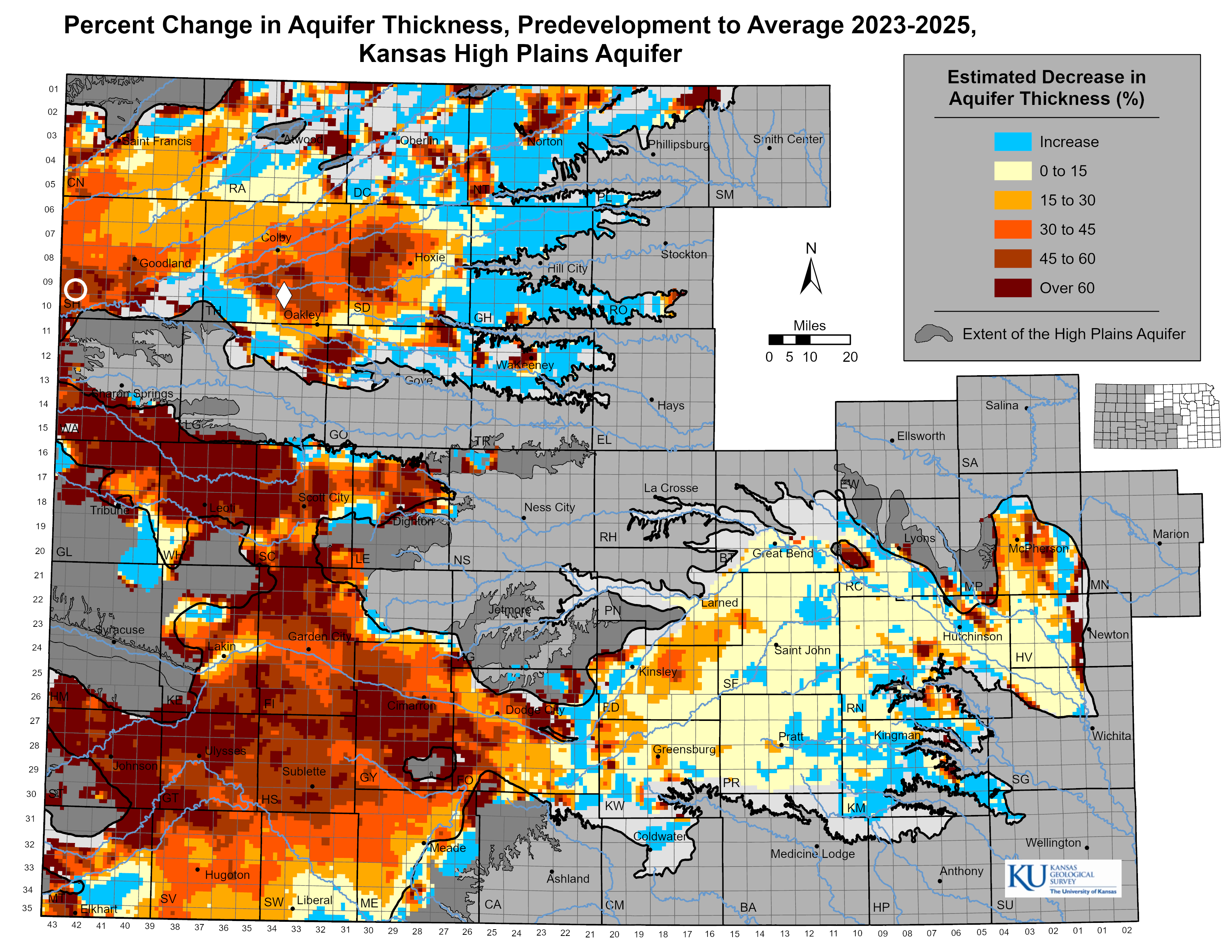
Click for larger image
Aquifers as Resources
The High Plains aquifer is the largest (and most pumped) aquifer system in the continental United States. It supplies about a third of the groundwater withdrawn for agricultural irrigation in the United States and provides drinking water for over 80% of the people that live within the aquifer’s boundaries.
The High Plains aquifer supplies over 90% of the water used for Kansas agricultural irrigation, which is the primary use of water in the majority of the state’s counties; almost 89% of Kansas is either grassland or cropland. Agriculture accounts for over 80% of all water consumed in Kansas.
Economically, Kansas agriculture and related sectors provide more than 140,000 jobs and have an annual output of over $60 billion.
Compared to agriculture, municipal and domestic water consumption total less than 10% of all water annually used in Kansas. Most domestic groundwater consumption in Kansas occurs in the west due to lacking surface water. About 70% of the Kansas population is reliant on groundwater as a major source of drinking water; that number increases to 85% in rural areas.
Proportion of Water Source in Kansas
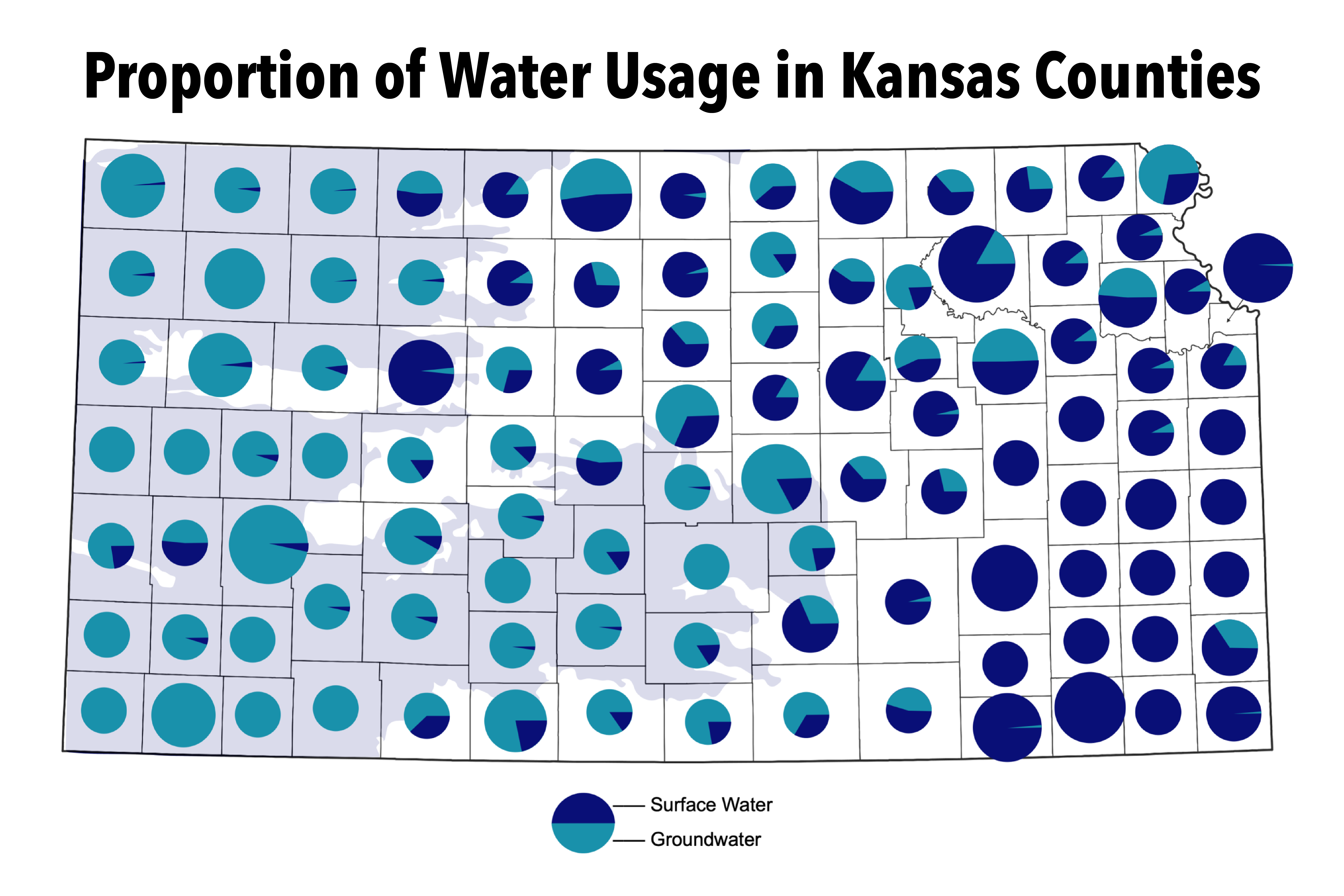
Click for larger image
Some Kansas counties mostly rely on surface water, and others rely on groundwater. This map shows the proportions of surface water and groundwater usage for each Kansas county. The shaded region underlying the left side of the map shows the extent of the High Plains aquifer in Kansas.
2024 Reported Water Use for Kansas Counties

Click for larger image
This map shows (a) how much water was used by each Kansas county in 2024, and (b) the proportional water usage of sectors within each Kansas county (industrial, municipal, irrigation, etc.). "AF" refers to acre-feet (one acre-foot is equivalent to nearly 326,000 gallons). For example, Finney County consumed 258,158 acre-feet of water in 2024, and about 90% of that water was used for irrigation.
Disclaimer
For the components listed below, the quantities and numbers in this game are approximations of influential factors affecting Kansas agriculture and are not necessarily proportionally reflective of real-life dynamics.
- Water available in the aquifer
- Prices received for crops and livestock products by farmers
- Cost of purchasing or implementing the “Upgrades”
- Water consumed in the production of each crop and livestock product and extracted from the aquifer
- Quantity of water required by crops/livestock in dry years as opposed to wet years
- Financial impact of shifting economic demands on agricultural products
- “Government Subsidies”
To balance playability with educational value, the game uses simplified numbers and systems to illustrate how agriculture interacts with groundwater.
OGALLALA was funded by the Kansas Geological Survey and a student research grant from the Geological Society of America.
Want to learn more about aquifers? Visit the Kansas Geological Survey’s Kansas High Plains Aquifer Atlas to explore maps and groundwater data!